Chapter 5 discusses using the GPS as a primary navigation tool.
Note, the displays for modern Chart Plotters have evolved, and are different from most GPS screens as shown in Weekend Navigator and the Student Manual. However, the principles and limitations of those tools are the same.
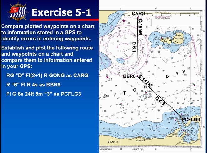
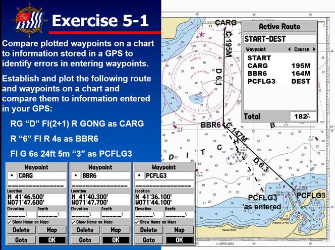
Exercise 5-1 demonstrates the results of an error when entering waypoints into the GPS. The results would be the same when using a Chart Plotter.
In this case, the error is transposing two digits in the longitude of PCFLG3.
Longitude of PCFLG3 as incorrectly entered: 71°44.1' W
Correct Longitude of PCFLG3: 71°41.4' W
The error results in a waypoint that is 2.0 nm away from the intended waypoint. In this case, the error does not cause a problem, but it could have easily "routed" the vessel over a navigational hazard.
This exercise allows the student to plan a route applying the knowledge gained so far in the course.
Create a qualified route from RW “OR” Mo (A) to RG “D” Fl R (2+1) GONG.
Identify sequence of legs on your route, course and distance of legs, reciprocal courses and waypoint names. Label all courses and waypoints properly.
Be prepared to discuss and justify your decisions. There are many correct plans. Err on the side of safety.
Select your vessel of choice and weather options from the lists following.
Vessel Options:
a. 32’ sail boat, draws 4.5’, 45’ mast plus radio antenna and wind instruments on top, max hull speed 6.8 knots.
b. 42’ sport fisherman, draws 3.0’, 25’ to top of observation tower, max speed 30 knots.
c. 26’ IO, draws 2’, max speed 20 knots.
Weather Options:
a. Partly cloudy, winds 10 to 12 knots from the NE, waves building 3 to 5 feet.
b. Sunny, winds variable 3 to 5 knots from the SW, a great day for boating.
c. Cloudy, winds 12 to 16 knots from the NW, visibility periodically obstructed, light drizzle.
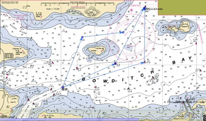
Solution:
There are no correct solutions. The image below gives several options, or you can choose one of your own.
Weather a:
A sailboat cannot sail closer than 45° to the wind. With winds and waves from NE, the sailboat may prefer a route west of Channel Island.
The other vessels may also want to head west of Channel Island, to get some shelter from building waves. They may also travel at reduced speed for more comfortable ride.
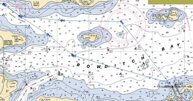
Weather b:
With "ideal" conditions, the power vessels may want to travel the shortest route at max or cruising speed. Wind direction is favorable for the sailboat to sail, choosing a course east of Channel Island, although the light winds may result in the sailboat using its engine.
Weather c:
With reduced visibility, vessels would travel at reduced speed. The route should steer well clear of the island or any other navigational hazards. For the sailboat, the NW wind is favorable for a route east of Channel Island, and the wind would tend to push it away from the island.
Exercise 5-3.
This is the second of four sequential exercises (EXERCISES 5-2, 5-3, 6-3 and 7-2). Integrate lessons learned to select a route and to implement real time on the water decisions.
Students will create routes, pre qualify them, plot them with course and distance, select and name waypoints, check GPS plot/entry accuracy, avoid hazards, and use handheld compass bearings and Seaman’s Eye concepts to validate bearings and fixes.
Create a qualified route from Perkins Cove to N “6” Shark River. Select your vessel of choice. Your weather is as listed. Identify sequence
of legs on your route, course and distance of legs, reciprocal courses and waypoint names. Label all courses and waypoints properly.
Be prepared to discuss and justify your decisions.
There are many correct plans. Err on the side of safety.