Finding the answers to the cruise is like solving a puzzle. You piece together the "clues" and determine your course and position, plotting on the chart.
Part of the challenge of the cruise is knowing where to start. Here is a list of the lat/lon positions of key locations in part 1 of the cruise. Latitude is in degrees N, longitude is degrees W. If you see any errors below, please let me know.
G “7” Fl G 4s 41° 37.4' N, 071° 50.0' W
G C “1” at the entrance to Blackfish Creek 41° 34.6' N, 071° 53.8' W
G C “3” within the Creek. 41° 33.9' N, 071° 54.4' W
G “3” Q G 41° 39.4' N, 071° 39.4' W
R N “2” near the breakwater at Perkins Cove 41° 36.3' N, 071° 42.4' W
Abandoned lighthouse west of Perkins Cove.41° 34.4557' N, 071° 42.0797' W
Fl R 6s 24 ft 5M “4” 41° 35.9' N, 071° 42.0' W
CHIMNEY to the west of Haven Bluff. 41° 33.4' N, 071° 50.6' W
The cruise is found in Appendix A, p 97 of the Student Manual.
The cruise is taken on Bowditch Bay. For all questions, use a variation of 15 W
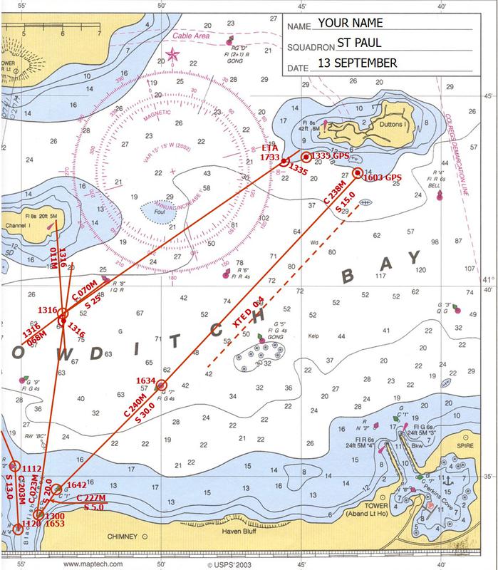
At the end of Part 3, your vessel is on a course of 238 M, approaching G "7" Fl G 4s.
Part 4:
13. You arrive at G “7” Fl G 4s at 1634 and you increase your speed to 30 kn.
Plot the 1634 fix at G "7".
Plot the course from G "7" to G C “1” . Measure the course and convert to magnetic, and label that leg.
T = 225°
V = 015 W
C = 240° M
You arrive at G C "1" at 1642. You slow down to 5.0 kn and enter the creek. You arrive at G C “3” at 1653. Measure the course to G C "3", convert to magnetic, and label that leg. Plot the 1653 fix at G C "3"
T = 212°
V = 015 W
C = 227° M
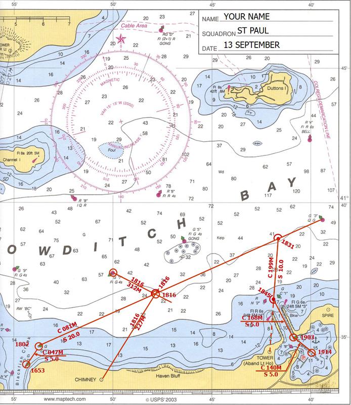
Since your course will now follow the range between the Tower and Fl R 6s, your plot will change. The "predefined" range was a dashed line. Now, the course line is 199M, so the range changes from a dashed line to a solid course line.
15. You pick up the range you developed at 1831 and change your course to 199° M. You follow the range to the entrance of Perkins Cove. You change speed to 10 kn.
Plot and label your course.
At 1845 you are between R N “2” and G C “1”. You change course to 168° M and slow down to 5.0 kn and continue to G C “7”. You arrive close aboard G C “7” at 1903.
Plot that leg of the voyage.
You must convert from magnetic to True.
T = 153°
V = 015 W
M = 168°
You change the course to 140° M and arrive close aboard the dock at 1914.
Plot that leg of the trip.
You must convert from magnetic to True.
T = 125°
V = 015 W
M = 140°
Plot that leg of the trip.
According to the text, the last leg of the trip lasted from 1903 to 1914. I used 60 D ST to estimate the length of that leg.
Time = 1914 - 1903 = 11 min
60 D = S T
D = 5.0 x 11
60
D = .92 rounds to .9 nm. I plotted this as a fix at 1914.
15. a Why can’t you head directly for the dock from G C “7” ? Because there are rocks between G C "7" and the dock
15. b What publication would you look at to determine the time of sunset when you were planning the cruise? Daily newspaper
15c. If you had the GPS, what could you do differently? Identify R N “2” off of Perkins Cove as a waypoint.
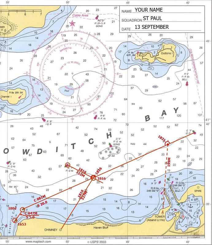
You return to G C “1”. You plan to travel to Perkins Cove.
The most logical course would be to go to R N “2” near the
breakwater at Perkins Cove. However, the sunset will be at 1821 and the entrance to the cove could be dangerous in darkness.
The abandoned lighthouse (Tower) west of Perkins Cove (L 41° 34.5' N, Lo 071° 42.1' W) is illuminated.
You plan to use the tower and the Fl R 6s 24 ft 5M “4” beacon (L 41° 35.9' N, Lo 071° 42.0' W) as a range, to lead to the entrance of the cove.
Plot and label the range. Hint: use a dashed line for a "Predefined Range" as shown in Figure 13 of the "Plotting and Labeling Standards."
13. What is the bearing of the range?
Measure the range (true) and convert to magnetic bearing. Label the range.
T = 184°
V = 015 W
C = 199° M
The bearing of the range is 199° M
To avoid the breakwater you lay a course of 081° M for G “3” Q G . Your speed will be 20 kn. Plot the 081° M course.
14. You leave G C “1” at 1802 and proceed as planned. Plot the 1802 fix.
At 1816 you decide to monitor your progress. With your hand bearing compass you take a bearing of 227° on the CHIMNEY to the west of Haven Bluff. At the same time, you take a bearing of 312° on G “7” Fl G 4s to your
northwest.
The FIX indicates you are right on course and coincides with your DR plot.
First, calculate and plot your 1816 DR.
Time = 1816
- 1802
0014 min
60 D = S T
D = 20 x 14
60
D = 4.67 = 4.7
Then, plot and label the bearings on the chimney and G "7":
Chimney G "7"
T = 212° T = 297°
V = 015 W V = 015 W
C = 227° M C = 312° M
Plot and label the 1816 fix.
Calculate the ETA of the intersection of the 081° M course with the 199° M range.
Measure the distance from your 1816 fix to the intersection of the course with the range. Calculate the time required to travel that distance.
60 D = S T
60 x 5.1 = T
20.0
T = 15.3 round to 15 min.
ETA:
1816
+ 0015
1831
14. a What is the ETA of the intersection of the course and range?
ETA = 1831
14. b What is the position of the intersection of the course and the range?