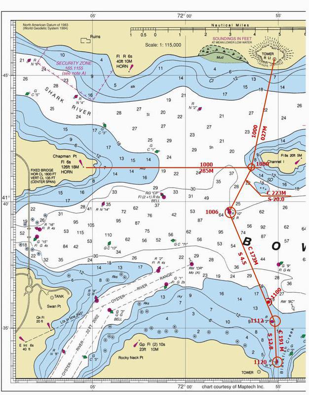
Tower R Lt on the hill to the north, 41° 45.6' N, 071° 55.2' W
Chapman Point light Fl 6s 18M HORN. 41° 41.4' N, 072° 05.5' W
R “10” Q R 41° 39.6' N, 071° 57.6' W
R N “2” the entrance to Blackfish Creek 41° 35.3' N, 071° 55.2' W
R N “4”. 41° 33.6' N, 071° 55.1' W
G C “3” at the entrance to Blackfish Creek 41° 33.9' N, 071° 54.4' W
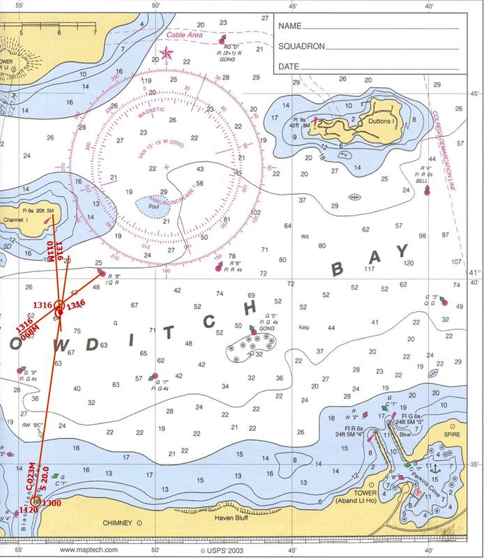
Fl 8s 20 ft 5M beacon on Channel Island 41° 41.7' N, 071° 53.8' W
R “8” I Q R 41° 40.2' N, 071° 51.9' W
The cruise is found in Appendix A, p 97 of the Student Manual.
The cruise is taken on Bowditch Bay. For all questions, use a variation of 15 W
4. Take bearings to establish your 1000 position.
The bearing to the Chapman Point light Fl 6s 18M HORN is 285°M
and the bearing to the Tower R Lt north of Channel Island is the same as your previous reading – 027° M
What is the L & Lo of 1000 FIX?
Tower Chapman
T = 012° T = 270°
V = 015° W V = 015° W
M = 027° M = 285°
Plot and label each bearing. The intersection of these two bearings is a fix. Plot and label the 1000 fix.
What is the L & Lo of 1000 FIX?
4. L 41° 41.4’ N, Lo 071° 56.4' W
5. Plot and label a course from the 1000 FIX to R “10” Q R. You proceed at a speed of 20 kn.
Measure distance to R “10” Q R
D = 2.0
Then, determine time to travel 2.0 nm
D = 2.0
60 D = ST
60 * 2.0 / 20.0 = T
6.0 = T
ETA:
1000
+ 0006
1006
5a. ETA at R “10”Q R = 1006
5b. Measure course from 1000FIX to R “10” Q R, then convert to magnetic
T = 208°
V = 015° W
M = 223°
5b. What is your course from 1000FIX to R “10” Q R? 223° M
6. You arrive at R “10”Q R at your estimated time (1006)., Plot a course from R “10”Q R to R N “2” at the entrance to Blackfish Creek. Reduce speed to 4.5 kn.
Plot and label the fix at 1006.
Plot and label the course to R N “2”
T = 158°
V = 015° W
M = 173°
6a. What is the course? 173° M
Plot the 1100 DR position
Determine time to 1100
11 hr 00 min
-10 hr 06 min
54 min
60 D = ST
D = 4.5 * 54
60
D = 4.05 = 4.1 (round up)
Plot 1100 DR on course line
Determine L/Lo
6b. 1100 DR position is: L 41° 35.8’ N Lo 071° 55.5’ W
7. Arrive at R N “2” at 1112. Plot a course to R N “4”. You increase your speed and arrive at 1120.
Plot and label the 1112 fix
Plot and measure the course to R N “4”. Label the leg.
T = 176°
V = 015° W
M = 191°
7a. Why didn’t you plot your course directly to R N “2” from your 1000 position?
Stay well off the Submerged rocks SW Channel Island
7b. Determine your average speed from R N “2” to R N “4”
Determine the time you traveled on this leg. Measure the distance of this leg.
Calculate your average speed
11 hr 20 min
-11 hr 12 min
8 min
D = 1.7
60 D = ST
60 * 1.7 = S * 8
60 * 1.7 / 8 = S
S = 12.75 = 12.8 (round up)
7b. average speed 12.8 kts
8. You depart from G C “3” at at 1300 and lay a course of 023° M at a speed of 20 kn.
Plot the fix at G C “3”. Label this course.
T = 008°
V = 015° W
M = 023°
At 1316 take a bearing on the Fl 8s 20ft 5M beacon on Channel Island of 011°M. Take another bearing on the R “8”I Q R buoy. of 068°M. Plot the two bearing FIX.