Finding the answers to the cruise is like solving a puzzle. You piece together the "clues" and determine your course and position, plotting on the chart.
Part of the challenge of the cruise is knowing where to start. Here is a list of the lat/lon positions of key locations in part 1 of the cruise. Latitude is in degrees N, longitude is degrees W. If you see any errors below, please let me know.
G C “5”  41° 33.9' N, 072° 05.5' W
R “4” Q R 41° 36.1' N, 072° 04.8' W
G “3” Q G 41° 35.7' N, 072° 04.1' W
Qk Fl 20 ft 41° 34.9' N, 072° 07.2' W
E Int 6s 40 ft 41° 34.5' N, 072° 08.6' W
R “2” Fl R 4s 41° 37.3' N, 072° 01.5' W
G “1” Fl G 2s. 41° 36.7' N, 072° 01.0' W
RW “OR” Mo (A). 41° 37.5 ' N, 071° 59.7' W
Tower R Lt on the hill to the north, 41° 45.6' N, 071° 55.2' W
Chapman Point light Fl 6s 18M HORN. 41° 41.4' N, 072° 05.5' W
R “10” Q R 41° 39.6' N, 071° 57.6' W
HW Questions about Cruise
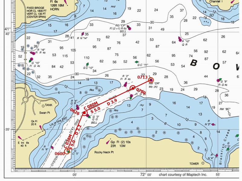
Refer to the chart below. Starting point for the cruise is on the lower left hand corner of the Bowditch Bay chart.
1. You plan to leave G C “5” buoy, on a course for mid channel between R “4” Q R and G “3” Q G. Measure Course with Course Plotter and Distance with dividers. Plot this leg of the cruise.
You leave your starting point, G C "5", at 0600. This gives you a fix - the buoy and the time. Label the fix, a circle, with the time, parallel to the bottom of the chart.
Determine your true course, then magnetic course. Label course line with the magnetic heading.
You can measure the distance of this leg with your dividers and the latitude scale.
T = 023°
V = 015 W
C = 038° M
D = 2.2
1a. True 023°
1b. Magnetic 038°
1c. Distance 2.2 nm
1d. ETA 0626
60 D = ST
60 * 2.2 / 5.0 = T
26.4 = T
0600
+ 0026
0626
When a change is made to the course, or speed of the vessel, you plot the DR. The symbol for a DR is a semicircle, with a dot at the center. The time of the DR is labeled at an angel to the bottom of the chart - usually around 45°.
1e. New Course is Reciprocal of the range:
True Range = 245°
Reciprocal - 180°
T 065°
V 015 W
1e. C 080°M
1f. Determine ETA mid channel between R “2” Fl R 4s and G “1” Fl G 2s.
You can draw a "construction line" (dotted line) between R “2” Fl R 4s and G “1” Fl G 2s. Measure the distance from your 0626 DR.
Determine the time to travel that distance, then add it to your 0626 time.
D = 2.6
60 D = ST
60 * 2.6 / 5.0 = T
31.2 = T
0626
+ 0031
0657
1f. 0657
1g. Measure the position of 0700 DR
Time to 0700 DR is 0700 - 0657 = 3 minutes
60 D = ST
D = 5.0 * 3 / 60
D = .25 round to nearest tenth = 0.3
Plot the 0700 DR on the course line
Measure the L/Lo to be:
1g. L 41° 37.1' N, Lo 072° 01.0' W
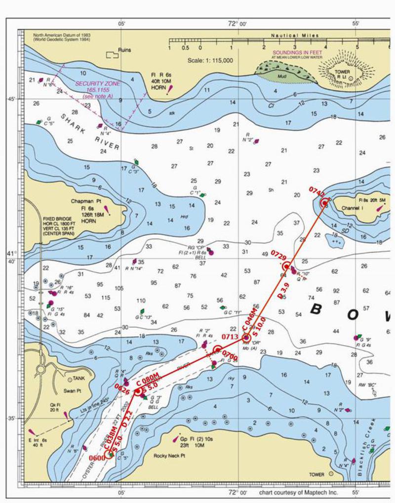
Plot 0713 arrival at RW "OR" as a fix.
Refer to chart below.
2. From 0713 Fix. Change course to 031° T.
T = 031°
V = 015 W
C = 046° M
2a. C = 046° M
2b. ETA at R"10"QR: (seaman's eye - R"10" QR is abeam)
Draw a construction line perpendicular to your course line through R"10"QR. Measure distance from 0713 fix.
D = 2.6
60 D = ST
60 * 2.6 / 10.0 = T
15.6 = T
0713
+ 0016
0729
2b. 0729
2.c Measure distance from 0713 fix to 8' sounding
D = 4.8
60 D = ST
60 * 4.8 / 10.0 = T
28.8 = T
0713
+ 0029
0742
2c. ETA 0742
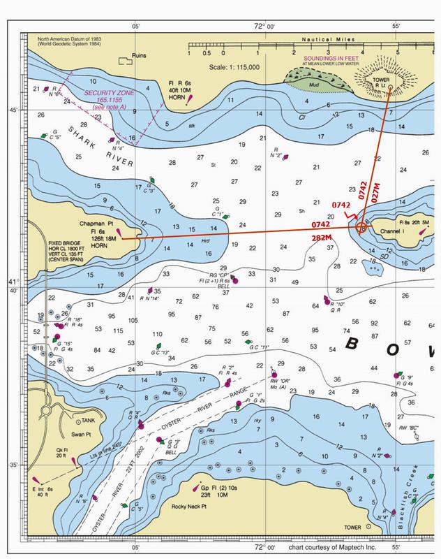
3. Refer to chart below. For clarity, only the 0742 bearings and fix are shown. Also for clarity, the label for the 0742 fix is a short distance away from the fix, with an arrow to the fix symbol (circle). The label "0742" is parallel to the edge of the chart
At 0742, you take bearings on Tower R Lt on the hill to the north, and Chapman Point light Fl 6s 18M HORN, with hand bearing compass, to plot a fix. Remember that the magnetic bearings must be converted to true before plotting.
Tower Chapman
T = 012° T = 267°
V = 015 W V = 015° W
C = 027° M M = 282°
Plot and label each bearing. The intersection of these two bearings is a fix. Plot and label the 0742 fix.
3.1 L 41° 41.7' N, Lo 071° 56.2' W